
Mapping Dwarf Lake Iris at Gilson Creek
Dr. James Horn did some plant inventory work in Door County. His report is titled “31 May 2017: Gilson Creek, Iris lacustris samples”. See the excerpt below. He did a terrific job of geotagging his observations. He used Degree Minute Second notation because it’s the approach he was taught and is comfortable with.
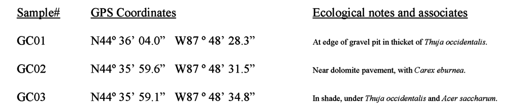
DMS is the most complicated notation for writing coordinate pairs. That opens the door to errors when moving DMS coordinates into a format understood by GIS software. Because Dr. Horn’s table was so well-constructed, it was very easy to import in to Excel.
- Leading zeroes are used so that all the data lines have the same structure. This is very helpful when writing an Excel formula to extract the numeric values from the text strings.
- Inclusion of °, ‘ and ” symbols assures that users can tell how fractions of degrees are recorded.
- The coordinate pairs include hemisphere indicators, in this case the “N” and “W”, to convey the global location of the data (north of the Equator and west of the Prime Meridian). The hemisphere indicators also make it clear which part of the pair is the latitude and which is the longitude.
Elsewhere in these pages we’ve noted that GIS practitioners prefer Decimal Degree notation. That’s true, but only a complete wimp would complain about geotags recorded as thoroughly and consistently as the ones in this example.
Comments are closed.